


Mobile Topographer GIS


Περιγραφή του Mobile Topographer GIS
Το αγαπημένο σας
Mobile Topographer
...συναντά το...
GIS
.
Τώρα πιά μπορείτε να κάνετε μία πλήρη αποτύπωση, χωρίς κανέναν περιορισμό στην πολυπλοκότητα ή το πλήθος των δεδομένων.
Δοκιμάστε τώρα το Mobile Topographer GIS χρησιμοποιόντας την τριήμερη δοκιμαστική περίοδο. Απλά εγκαταστείστε την εφαρμογή και προχωρήστε στη διαδικασία αγοράς συνδρομής. Παρόλο που θα σας ζητηθεί να δώσετε πληροφορίες χρέωσης, ΔΕΝ θα χρεωθείτε πριν από τη λήξη της τριήμερης δοκιμαστικής περιόδου. Μπορείτε να ακυρώσετε τη συνδρομή σας οποιαδήποτε στιγμή μέσα στην τριήμερη δοκιμαστική περίοδο χωρίς καμία χρέωση. Χρέωση θα γίνει μόνο μετά το τέλος της τριήμερης δκιμαστικής περιόδου και μόνο εάν έχετε ακόμη ενεργή συνδρομή.
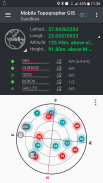
- Συγκεντρώστε σημεία με το δέκτη GNSS χρησιμοποιώντας αυξημένη ακρίβεια (πλήρης υποστήριξη για GPS, GLONASS, Galileo, Beidou και QZSS).
- Υποστήριξη εξωτερικών δεκτών GNSS μέσω χρήσης ψευδών τοποθεσιών (mock locations).
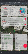
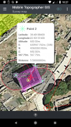
- Δείτε τα δεδομένα σας σε μορφή WGS84 ή στο τοπικό καρτεσιανό σύστημα συντεταγμένων (Πλήρης υποστήριξη ΕΓΣΑ87 και HTRS07 - HEPOS).
- Μετατρέψτε συντεταγμένες από γεωδαιτικές WGS84 στο τοπικό καρτεσιανό σύστημα συντεταγμένων και αντίστροφα.
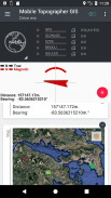
- Προβολή στο χάρτη σε πραγματικό χρόνο.
- *** ΝΕΟ *** Χρήση φωτογραφίας ή WMS server ως υπόβαθρο χάρτη.
- Βρείτε ένα αποθηκευμένο σημείο στο πραγματικό πεδίο με τη χρήση της λειτουργίας "Οδήγησέ με"
- Υπολογίστε το ορθομετρικό υψόμετρο σε πραγματικό χρόνο χρησιμοποιώντας το μοντέλο EGM ή τοπικούς κανάβους όπου αυτοί είναι διαθέσιμοι.
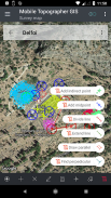
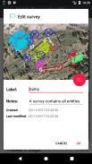
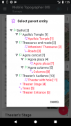
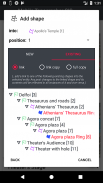
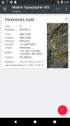
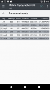
- Οργανώστε τις εργασίες σας σε Σημεία - Σχήματα - Οντότητες & Τοπογραφήσεις.
- Μπορείτε πια να αποτυπώσετε ανεξάρτητα σημεία, ομάδες πολλαπλών σημείων, πολυγραμμές με σκέλη ή πολύγωνα με τρύπες σύμφωνα με τα πρότυπα της επιστήμης του GIS.
- Κατασκευάστε ένα πλήρες σχέδιο με όσες λεπτομέρειες επιθυμείτε.
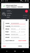
- *** ΝΕΟ *** Γεωδαιτικά εργαλεία: Προσθέστε σημεία μέσω μίας από τις ακόλουθες επιλογές: 1 σημείο + Απόσταση + Αζιμούθιο, 2 σημεία + Αποστάσεις + Επιλογή, 2 σημεία + Αζιμούθια, 3 σημεία + Αποστάσεις, Μέσο ευθείας, Χωρισμός ευθείας, Επέκταση ευθείας, Παράλληλη γραμμή σε απόσταση, Παράλληλη γραμμή από σημείο, Κάθετη γραμμή.
- Ενσωματώστε μία υπάρχουσα τοπογράφηση μέσα σε μία άλλη, σε οποιοδήποτε βάθος ώστε να δημιουργήσετε μία υπερ-τοπογράφηση που περιέχει τις υπόλοιπες.
- Μοιραστείτε δεδομένα μεταξύ των τοπογραφήσεων με ενεργούς συνδέσμους.
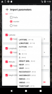
- Μεταφέρετε τις τοπογραφήσεις σας μεταξύ των φορητών συσκευών σας και του υπολογιστή σας με τις λειτουργίες "Εισαγωγής - Εξαγωγής" χρησιμοποιώντας όλα τα γνωστά πρότυπα αρχείων .txt, .csv, .kml, .gpx, .dxf και Shape files (.shp - .shx - .dbf)
- Συνεργαστείτε με τους συναδέλφους σας ανταλλάσοντας από ένα σημείο έως μία ολόκληρη τοπογράφηση.
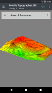
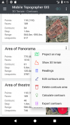
- Δημιουργήστε το τρισδιάστατο μοντέλο μίας περιοχής, απλά περπατώντας μέσα σε αυτή.
- Υπολογίστε τις ισοϋψείς και προσθέστε τες σε μία τοπογράφηση άμεσα.
- Δείτε και διορθώστε το τρισδιάστατο μοντέλο κατευθείαν στη φορητή συσκευή σας.
- Αποθηκεύστε μία διαδρομή και επεξεργαστείτε τα δεδομένα της.
- Δείτε τους δορυφόρους GNSS και την ισχύ του σήματός τους τόσο σε προβολή πυξίδα όσο και σε επαυξημένη πραγματικότητα.
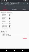
- Δημιουργήστε και επαναφέρετε αντίγραφα ασφαλείας των δεδομένων σας χρησιμοποιώντας αρχεία τύπου SQL .db.
Μάθετε περισσότερα για το Mobile Topographer GIS στον ιστότοπό μας:
http://applicality.com/projects/mobile-topographer-gis/
Κατεβάστε το εγχειρίδιο χρήσης από το:
http://applicality.com/app_documentation/web/MobileTopographerGIS_Manual.pdf
Mobile Topographer GIS - Έκδοση 6.0.15
(23-06-2023)

Mobile Topographer GIS - Πληροφορίες APK
Έκδοση APK: 6.0.15Πακέτο: com.applicality.mobiletopographergisΤελευταία έκδοση του Mobile Topographer GIS
Άλλες εκδόσεις


Εφαρμογές στην ίδια κατηγορία

Μπορεί επίσης να σου αρέσουν...


